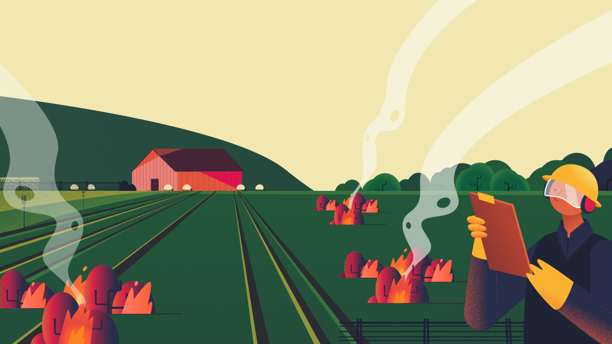
Goats, tractors and controlled burns to prevent intense wildfires in Europe
The way we manage land, or rather, the way we don’t do it, worsens fire risk conditions in some areas as much as climate change does in others. Common activities such as grazing by herbivores, mechanical removal of fuels by people or machines, or prescribed fires could be one of our best chances to prevent future wildfires in Europe. In this post, we revise with Alex Neidermeier, a scientist researching the Adaptation perspective of the FireEUrisk project, some of the latest works on the suitability of different land management strategies in European countries, and the prediction of future scenarios of how our continent could be affected by wildfires based on how we make use of the land.
During the past years, different regions in Europe have experienced more intense and more frequent wildfires than usual. In the Northern part of the continent, climate change has been pointed out as the main culprit by experts, for causing a greater prevalence of droughts, high winds, or high temperatures that enhance fire risk. However, what most people might not know is that, in the Southern part, wildfires happen frequently and persist mainly due to landscape changes in large swathes of abandoned lands.
Alex Neidermeier, a PhD candidate at the Institute for Environmental Studies (IVM), Vrije Universiteit Amsterdam, helps us understand why land use plays an important role in fire risk management. Her research is part of the FirEUrisk project and a few months ago she presented important results to help European countries make decisions on where and how to invest efforts to implement Land Management Strategies.
“After the Second World War important demographic changes occurred, incentivizing people to leave their rural lives to pursue economic opportunities in the cities, and a lot of countryside areas that were well managed before were just left alone,” Alex explains. But why does this increase fire risk in such an impactful way? In this type of land, vegetation can start to grow spontaneously, becoming very dense and homogenous. And that’s the problem. A fuelscape —the layout of fuels on a landscape— with homogeneous properties like structure and age is more susceptible to fire. The importance of analysing fuels for understanding fire behaviour was addressed in our last blog post, now we will focus on how we can act on fuelscapes in Europe to change them in our favour.
In their recently published paper, Alex and her team chose three Land Management Strategies (LMS) that reduce fire risk, or at least diminish wildfire intensity, and mapped their suitability in all parts of Europe. These are: grazing by domesticated herbivores like sheep or goats or by wild herbivores like deer; mechanical removal, meaning any kind of vegetation removal by people or machines; and prescribed burn, which is intentional and highly controlled burning by experts. All of them are common practices that have been performed in Europe for centuries and help create more heterogeneity in fuelscapes. Their implementation depends on a lot of different factors such as the diversity of species present in each area, geographical and socio-economic characteristics, or prevailing weather conditions. The most relevant and appropriate factors were considered and Alex’s team created a map for each of the LMS that shows in which areas of high and medium fire risk in Europe they can be implemented. Then they combined all of them in just one map and analysed the results.
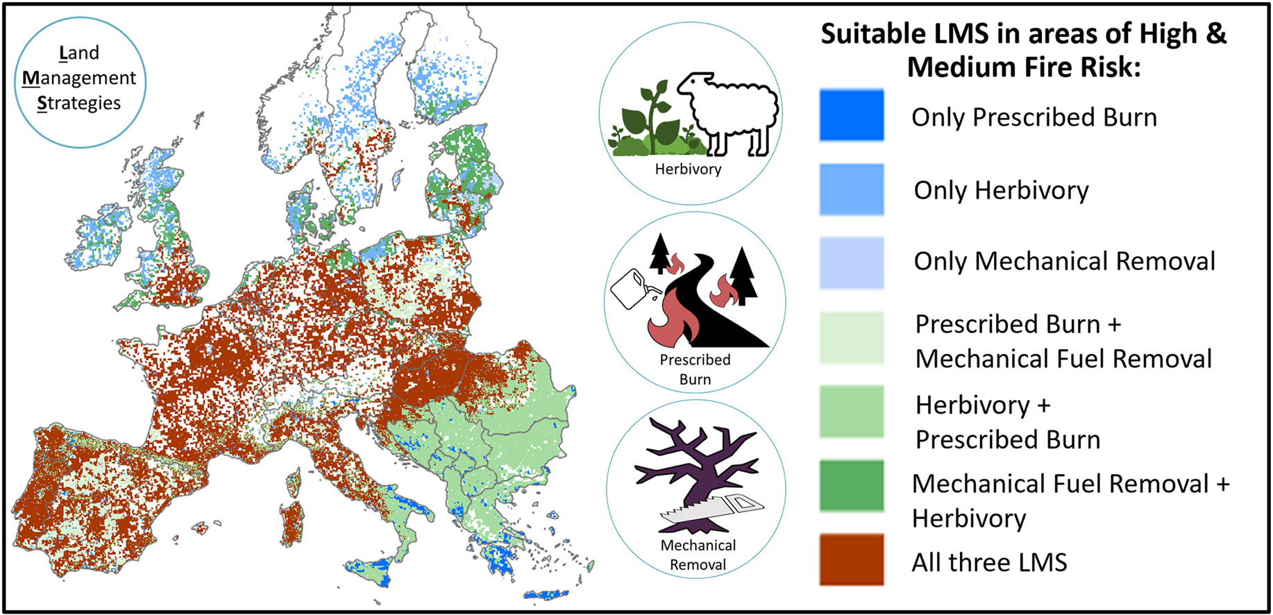
Mapping opportunities for the use of land management strategies to address fire risk in Europe-Graphical Abstract
They obtained important results that have already been useful for introducing solutions against this new worrying fire tendency. “One of the things we found was that prescribed burning was the only strategy that was suitable in Greece. But it’s illegal to do prescribed burning in there. So, looking at our paper they’ve been trying to make a case to the government for a while to make it legal,” Alex says. In addition to this important result, the map shows that over a quarter of Europe is suitable for more than one type of Land Management Strategy, in areas where fires have been historically frequent.
Currently, these researchers are already focused on taking another step. With land use and vegetation models they are exploring Europe’s future fuelscapes to know more about how fire risk might change if, for example, some of these land management strategies are applied. Dr Peter Verburg, professor in IVM’s Environmental Geography department and Alex’s PhD supervisor, developed CLUMondo, a Land Use Model that hadn’t been used for research on fire risk until now. As Alex explains, “CLUMondo essentially plays out a game of Catan for you of what future land use might be like”. She found an analogy between the model and this board game, where players need to settle on different types of land by managing the different resources at stake.
In collaboration with FirEUrisk project partners at Potsdam Institute for Climate Impact Research (PIK) with expertise in dynamic global vegetation modelling, scenarios of grazing, mechanical removal, or prescribed burning will be tested to understand their potential to reduce burned areas in the future. Having reliable data that supports the effectiveness of these strategies, contributes to the aims of the FireEUrisk project, by helping governments in Europe to look at the big picture and make the most appropriate decisions regarding future fire management.
Certainly, Alex’s team’s work provides valuable information to help take action on an urgent issue for the continent and is a good example of the progress this European project is making against wildfires to take care of our futures. But, above all, it makes us aware of the potential hidden in the management of the fuels that are part of our lands.
