Why we classify fuels for wildfire prevention
A European approach to understanding fire behaviour

In the first FirEUrisk training event we presented a new classification system for fuels and a European fuel map. Being a key step towards our project goals, we want to shed a light on its importance as a tool for better management and, essentially, reduction of wildfire risk.
Every year Europe faces fires on a massive scale. Around 5.000 km2 are burnt in the continent per year according to the European Commission. The impact of these wildfires depends on various reasons, but fuels — all kinds of combustible biomass that can start a fire — play a huge role in fire behaviour. This is why studying them is extremely important to improve wildfire prevention and management.
Having a system that categorises fuels is necessary for “understanding how fires behave in any type of fuel”, says Elena Aragoneses, researcher of the FirEUrisk project from the University of Alcalá and main author of this tool.
One of the objectives of Aragoneses and her team was to create a common system that can be applied to all European countries, through general categories that are easily comparable across regions. “One of the problems we faced is that many fuel classification systems were very site specific, only referring to a certain country or region, which made them difficult to compare to others”, she explains.
The new system aims to solve this issue by creating groups of fuels that can be found anywhere in Europe. It divides fuels into 6 types and a nonfuel category, with subcategories extending up to 24 different fuel types:
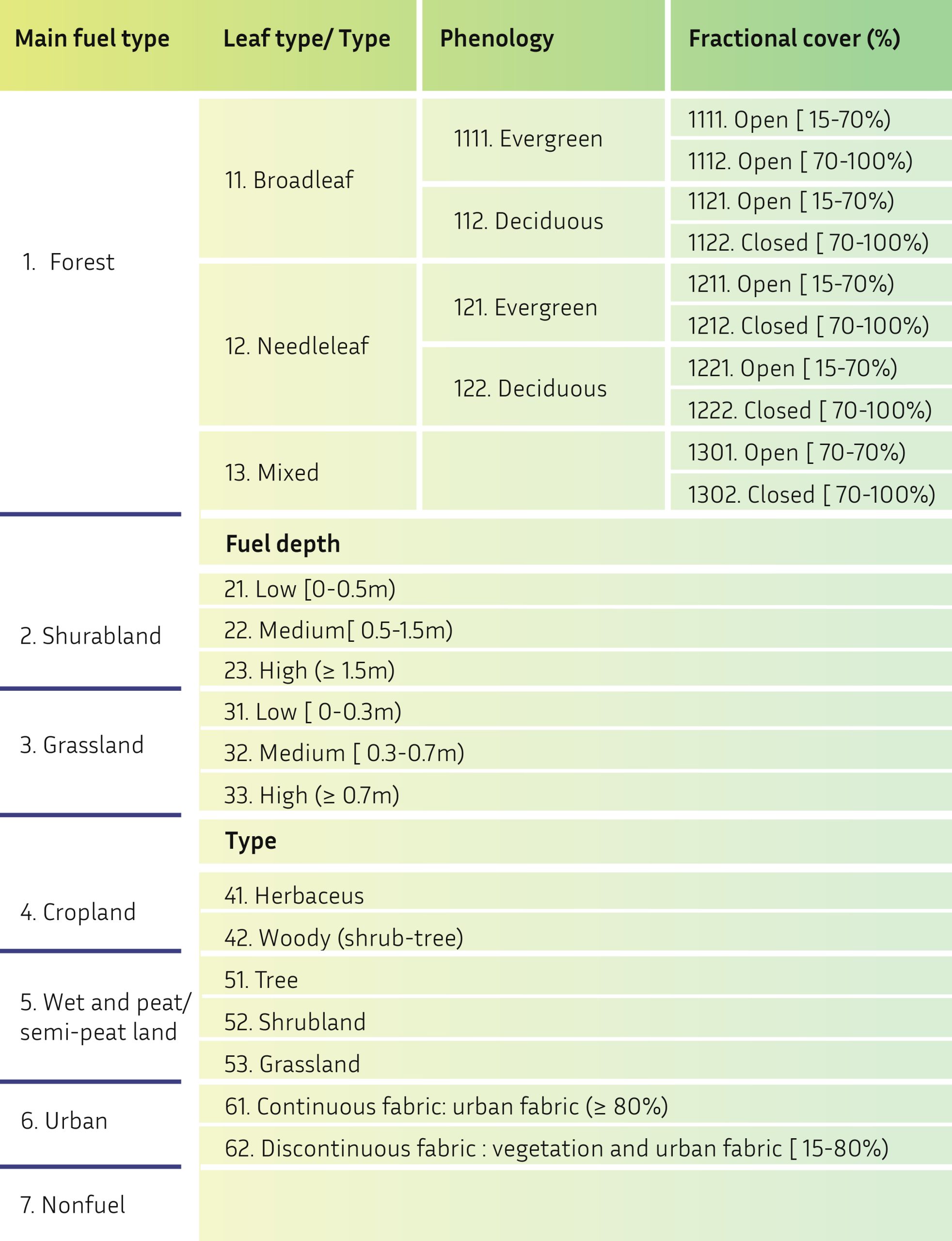
The next step is to give numerical values to the fuels so that fire behaviour and propagation models can be run. The classification is also hierarchical, allowing it to go into more or less detail in each category and giving third parties the opportunity to continue introducing more fuel types, which can be useful for certain areas.
The behaviour of fires not only depends on the types of fuels but on climate conditions too, such as precipitation or wind speed, and also on the characteristics of trees — height, type of wood — or the distance between them. Two scenarios with the same type of fuel could end up being different in many aspects, which is why parameterising fuel types will give more information to work on reducing risk.
Along with this classification, the different fuels present across Europe were placed on a map. It gives researchers the resources to better understand fire risk, while fire managers and mitigators can use it to understand how a fire might behave. The map is also useful for policy-making regarding fire prevention.

Looking at the map, in Central and Southern Europe the most predominant fuels are croplands, whilst in Northern Europe these are forests. The quick speed of spreading and the dryness of many herbaceous croplands contribute to the difficulty of controlling and mitigating fires in these areas.
Moreover, forest trees, although more difficult to ignite, can cause crown fires which occur in the canopies of trees, being often dangerous and difficult to extinguish. Understanding fire behaviour at the canopy level was another goal that Elena Aragoneses had in mind, because “normally fuel classification systems only refer to surface fields. We wanted to also include one of the most extreme types of fires”, she explains.
The fuel classification system and mapping is a major milestone for the FirEUrisk project. It is a useful tool in itself because it can be used by many actors in the field of fire risk. “But it will be much more important when it is integrated with the other parts of our project and combined with the rest of variables and work of the different research groups”, Aragoneses concludes.
