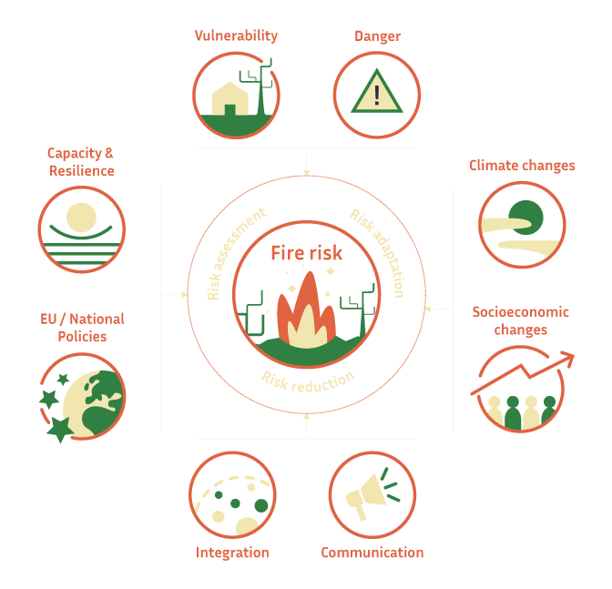
FirEUrisk novel approach
Three angles to understand wildfire risk
We combine the best wildfire management practices available in Europe into a strategy that covers the assessment of the vulnerability of communities, the risk reduction by integrating societal factors and communication into the equation and the adaptation to the future climate and socioeconomic conditions.
Piloting throughout Europe
We evaluate fire risk across space and time
Wildfire risk changes from one area and time period to another. Our strategy considers risk conditions within different temporal and spatial scales to ensure realistic risk assessment, reduction and adaptation.

Temporal scales
- Hourly and daily: We take into account weather parameters and fuel state conditions, among others.
- Weekly and monthly: We look at things like fuel loads, seasonal weather patterns and human drivers of fire ignition such as holidays, management and debris burn.
- Annual and decennial: We consider demographic trends, vegetation succession, land-use, urban cover, road structure, legal or fire management systems, and climate.
- Stable: We also include variables that are more static, such as topography, in our approach.

Spatial scales
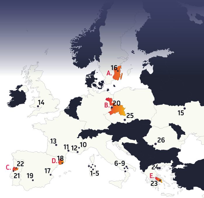
- Demonstration areas: The 26 demonstration areas (see map below) are our smallest testing fields for applying new methodologies and risk elements in practice.
- Pilot sites: Our five pilot sites (see map below) cover wildfire risk conditions in regions in Mediterranean,Central, Eastern and Northern Europe. We use the sites for upscaling the solutions tested locally in the demonstration areas.
- European territory: The whole European continent is the reference region for our integrated fire risk strategy, and the largest scale for testing our solutions.
Piloting throughout Europe
We evaluate fire risk across space and time
Wildfire risk changes from one area and time period to another. Our strategy considers risk conditions within different temporal and spatial scales to ensure realistic risk assessment, reduction and adaptation.
Temporal scales
- Hourly and daily: We take into account weather parameters and fuel state conditions, among others.
- Weekly and monthly: We look at things like fuel loads, seasonal weather patterns and human drivers of fire ignition such as holidays, management and debris burn.
- Annual and decennial: We consider demographic trends, vegetation succession, land-use, urban cover, road structure, legal or fire management systems, and climate.
- Stable: We also include variables that are more static, such as topography, in our approach.
Spatial scales
- Demonstration areas: The 26 demonstration areas (see map below) are our smallest testing fields for applying new methodologies and risk elements in practice.
- Pilot sites: Our five pilot sites (see map below) cover wildfire risk conditions in regions in Mediterranean,Central, Eastern and Northern Europe. We use the sites for upscaling the solutions tested locally in the demonstration areas.
- European territory: The whole European continent is the reference region for our integrated fire risk strategy, and the largest scale for testing our solutions.
Pilot sites
We test the FirEUrisk solutions regionally in five pilot sites across Europe
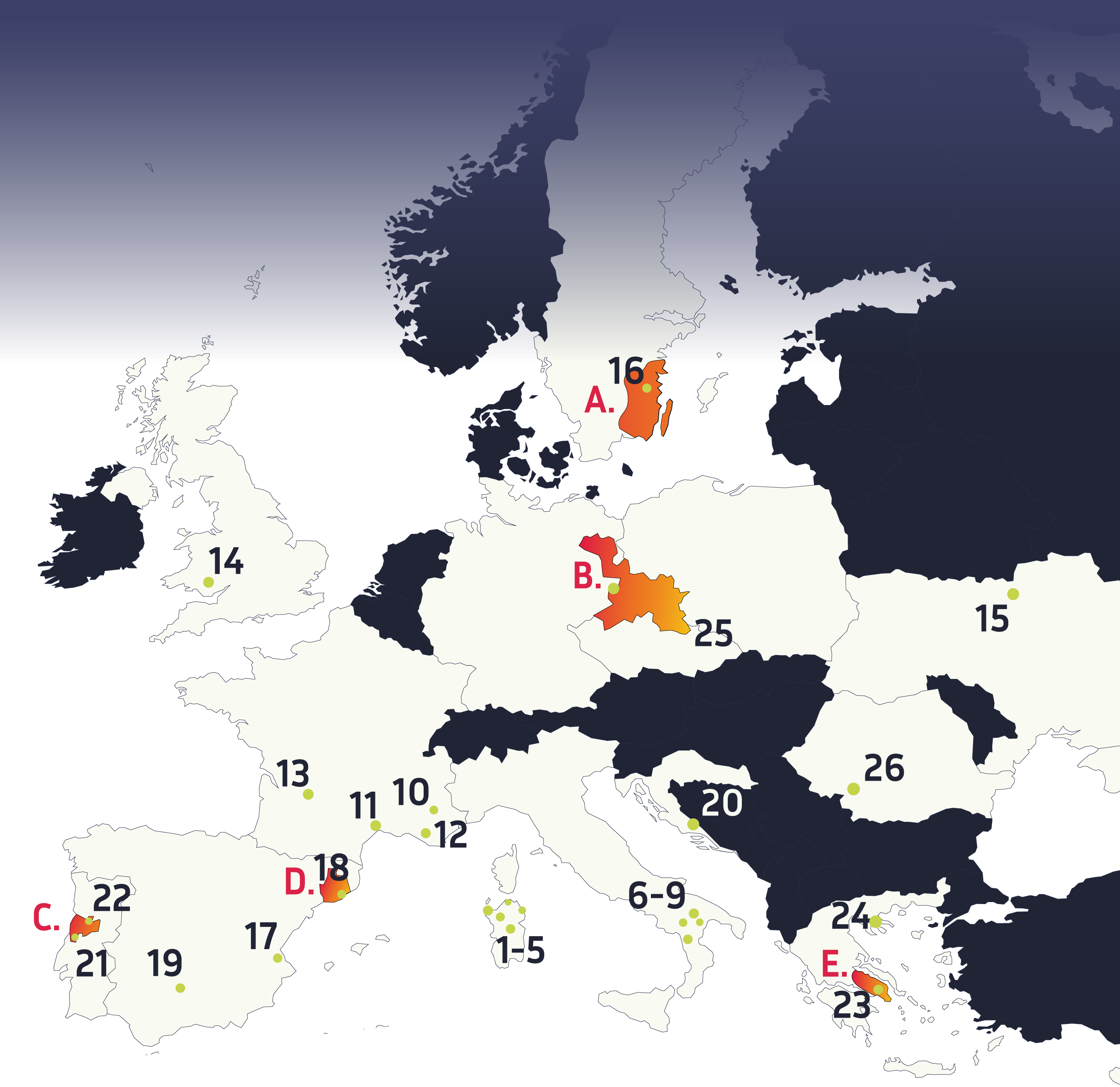
Demonstration areas
We apply our methods locally in these 26 demonstration areas
1. Municipalities of Suni and Sindia (Sardinia, Italy)
2. Municipalities of Tempio and Municipalities of Bonorva and Mores (Sardinia, Italy)
3. Municipalities of San Teodoro and Budoni (Sardinia, Italy)
4. Porto Conte Nature Reserve (Sardinia, Italy)
5. Sardinia, Italy
6. Municipality of Matera (Basilicata, Italy)
7. Lauria and Pollino (Basilicata, Italy)
8. Metaponto area, Ionia coast (Basilicata, Italy)
9. Basilicata, Italy
10. Alpes-de-Haute- Provence department (Alps, France)
11. Puechabon study site (Montpellier, France)
12. Rougiers community (Var department, France)
13. Corsica, Provence-Alpes-Côte d’Azur, Occitanie and Nouvelle Aquitaine (France)
14. Rhondda Cynon Taff (South Wales, UK)
15. Chernobyl contaminated area (Ukraine)
16. Kalmar county (Sweden)
17. Province of Valencia (Spain)
18. Collserola (Barcelona, Spain)
19. Sierra Morena of Córdoba (Spain)
20. Coastal side and hinterland of mountain Kozjak (Croatia)
21. Central Region of Portugal
22. Central Region of Portugal
23. Mati peninsula Rafina-Pikermi (Greece)
24. Taxiarchis Forest in Chalkidiki (Greece)
25. Křtiny Forest (Brno, Czech Republic)
26. Mehedinți (MH) and Gorj (GJ) counties (Romania)
Pilot sites
We test the FirEUrisk solutions regionally in five pilot sites across Europe
Demonstration areas
We apply our methods locally in these 26 demonstration areas
1. Municipalities of Suni and Sindia (Sardinia, Italy)
2. Municipalities of Tempio and Municipalities of Bonorva and Mores (Sardinia, Italy)
3. Municipalities of San Teodoro and Budoni (Sardinia, Italy)
4. Porto Conte Nature Reserve (Sardinia, Italy)
5. Sardinia, Italy
6. Municipality of Matera (Basilicata, Italy)
7. Lauria and Pollino (Basilicata, Italy)
8. Metaponto area, Ionia coast (Basilicata, Italy)
9. Basilicata, Italy
10. Alpes-de-Haute- Provence department (Alps, France)
11. Puechabon study site (Montpellier, France)
12. Rougiers community (Var department, France)
13. Corsica, Provence-Alpes-Côte d’Azur, Occitanie and Nouvelle Aquitaine (France)
14. Rhondda Cynon Taff (South Wales, UK)
15. Chernobyl contaminated area (Ukraine)
16. Kalmar county (Sweden)
17. Province of Valencia (Spain)
18. Collserola (Barcelona, Spain)
19. Sierra Morena of Córdoba (Spain)
20. Coastal side and hinterland of mountain Kozjak (Croatia)
21. Central Region of Portugal
22. Central Region of Portugal
23. Mati peninsula Rafina-Pikermi (Greece)
24. Taxiarchis Forest in Chalkidiki (Greece)
25. Křtiny Forest (Brno, Czech Republic)
26. Mehedinți (MH) and Gorj (GJ) counties (Romania)
